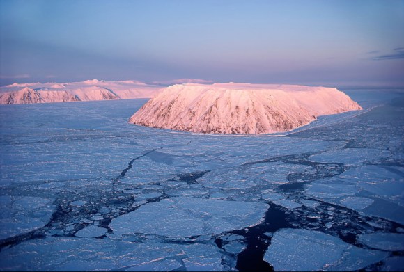
The Diomede Islands, also known in Russia as Gvozdev Islands, consist of two rocky, mesa-like islands:
The Russian island of Big Diomede (part of Chukotka), also known as Imaqłiq, Inaliq, Nunarbuk or Ratmanov Island.
The U.S. island of Little Diomede (part of Alaska) or Iŋaliq, also known as Krusenstern Island.
The Diomede Islands are located in the middle of the Bering Strait between mainland Alaska and Siberia. … Because they are separated by the International Date Line, Big Diomede is almost a day ahead of Little Diomede, but not completely; due to locally defined time zones, Big Diomede is only 21 hours ahead of Little Diomede (20 in summer). Because of this, the islands are sometimes called Tomorrow Island (Big Diomede) and Yesterday Island (Little Diomede).
The islands are named for the Greek Saint Diomedes.
During winter, an ice bridge usually spans the distance between these two islands. At these times, it is theoretically possible (although not legal, since travel between the two islands is forbidden) to walk between the United States and Russia.
Wikipedia
From NASA’s Earth Observatory

Here’s a bit of trivia to challenge your geography knowledge: Which country is closest to the continental United States without sharing a land border?
The answer is revealed in the top image, which shows the eastern part of Russia and western part of the United States…. At the narrowest part of the Bering Strait, about 82 kilometers (51 miles) is all that separates Cape Dezhnev on the Chukotka Peninsula and Cape Prince of Wales on mainland Alaska.
But Russia’s Big Diomede Island is even closer to mainland Alaska, about 40 kilometers (25 miles) away, making it the closest non-border-sharing country to the continental U.S.
The distance between the two countries is actually much smaller. Just 3.8 kilometers (2.4 miles) separate Big Diomede Island (Russia) and Little Diomede Island (U.S.)….
Summer temperatures on the islands average about 40 to 50 degrees Fahrenheit. Wintertime is even colder, averaging between 6 and 10°F. Each year, Arctic sea ice extends southward into the strait from the Bering and Chukchi seas. By June, however, melting usually causes the ice edge to retreat northward, leaving open water that appears black in these images.
NASA’s Earth Observatory


The Alaska Frontier
The Alaska Frontier has a nice article on the Diomede Islands, as well as other areas of Alaska where you can view Russia.
The distance from the mainland of Alaska to the Russian mainland across the Bering Strait is about 53 miles (85 kilometers). The water in the Bering Strait is very shallow, with an average depth of just 50 feet (15 meters).

There’s a Movie?
You betcha!

SYNOPSIS
In the dawn of the Cold War, a young Soviet telegraphist makes a desperate attempt to save her American lover from being stranded in the Russian side of the Bering Strait after receiving a border closure message.
Just Watch


Alaska Business Magazine: Alaska Crews Produce Documentary “At the Edge of Tomorrow”

Looking to the Future
The film depicts the challenges facing a small Native-owned construction company working to bring running water, sewer, and basic infrastructure improvements to the Iñupiaq community of Little Diomede. A story of resilience in the face of old and new rivalries, the effects of climate change, and honoring the past while looking to the future, At the Edge of Tomorrow was shot on location on Little Diomede Island, two miles from Russia’s Big Diomede Island separated only by the International Dateline—the divider between yesterday and tomorrow.
Alaska Business Magazine
There’s a Prankster[1] on the Internet!
Someone added a 24-hour museum in the middle of the Russia’s uninhabited Tomorrow Island. Apparently it is a comment on the state of Russian aviation.


[1] Meet the Team: WLBOTT Dept of Pranksterism
WLBOTT has an entire department dedicated to pagan pranksterism. Meet-‘n’-Greet!


Dept. of Pranksterism: Work from Home


